Journalist Resource
 July 26, 2023
How They Did It: Striving To Protect Mangrove Resources in Tanzania
Country:


Using remote sensing techniques and GIS, this project investigates the extent of the environmental...

A few months after the start of the construction of a massive hydropower plant in the Selous Game Reserve—a UNESCO World Heritage Site in Tanzania—the U.N. launched a conservation project in the very same region, bringing together local authorities, citizens, forest experts, and advocates around a new initiative for mangrove protection in the Rufiji Delta.
Mangrove forests represent a type of rainforest developing on marine coastal lines as well as various types of inland shores. They face the same deforestation threats and challenges as the rainforests of the Congo and Amazon basins. Less known and underreported, mangrove forests also represent a prime resource in carbon dioxide emissions reduction and are known as the "best carbon scrubber," as coined by NASA.
Using field reporting, remote sensing techniques, and a geographic information system (GIS), this project investigated the extent of the environmental damage caused by the dam project. The project's team attempted to give an estimate of the mangrove areas put at risk by the dam. Most notably, the team developed a provisional hydrological model created to simulate the upcoming changes in the Rufiji Delta's flow system.
Despite the team’s efforts, none of the information needed from the government or the companies involved in the project could be retrieved in order to draw this analysis, as explained below. The team resorted to a GIS analysis of species at risk (a dozen) on the dam’s construction premises, as well as a field report within the reserve.

As a nonprofit journalism organization, we depend on your support to fund journalism covering underreported issues around the world. Donate any amount today to become a Pulitzer Center Champion and receive exclusive benefits!
This controversial hydropower megaproject sparked “grave concerns” by the UNESCO World Heritage Committee, which ultimately called on the Tanzanian government to abandon it in 2020, according to the Environmental Investigation Agency (EIA). The main reason for this was insufficient research on the socio-environmental impacts linked to the dam.
The International Union for Conservation of Nature (IUCN) had even declared the dam project to be “incompatible” with the reserve’s UNESCO World Heritage status, based on the project’s Strategic Environmental Assessment (SEA), which a review found to be “completely inadequate.”
But could the alleged impacts of the dam on its immediate vicinity, as well as on the mangrove resources downstream of the Rufiji Delta, be precisely quantified and projected? And what more could we bring into this topic?
These are the questions Alexandre Brutelle, a Pulitzer Center Rainforest Journalism Fund grantee and director of the Environmental Investigative Forum (EIF)—a global consortium of environmental investigative journalists—was trying to answer, with the support of his fellow remote sensing expert and EIF colleague Christina Orieschnig.
While Brutelle is always on the lookout for new ways to report about countries where environmental impact assessment and public data are lacking, Orieschnig is often the key element of the team with regard to using remote sensing—specifically, spectral satellite imagery analysis—as a reporting practice.
“Such projects often start with a question of feasibility, that Christina always assesses for us,” says Brutelle. “While we have already used remote sensing to monitor unlawful flaring activity and methane emissions in Democratic Republic of Congo, or eutrophication levels following a wastewater treatment plant in Bulgaria, this Tanzanian topic was slightly different.”
The Julius Nyerere hydropower plant indeed includes several areas of impact—but it wasn’t actually active at the time of this investigation. Potential impact of mangrove forests in the region could take time. The IUCN and the UNESCO forecast an overall deforestation figure of 1000km2, but without any precision on which type of forest exactly it would apply to. Perhaps a predictive model could provide more information over these risks?
As a doctoral graduate and hydrology expert, Orieschnig felt she could develop such a model for the sake of the article, given she could access technical information about the dam. But to the surprise of everyone on the team, some key elements of the dam construction, such as its projected flowing levels, could not be found anywhere. None of the stakeholders of this project agreed to provide this key information.
The concerning absence of a flowing model still raises a question mark regarding the sake of the mangrove resources located downstream. To this day there is no reliable projection that the public and civil society would be available to verify. And despite this lack of transparency from the Tanzanian government on the matter, immediate negative impact was already evident, as Brutelle later realized.

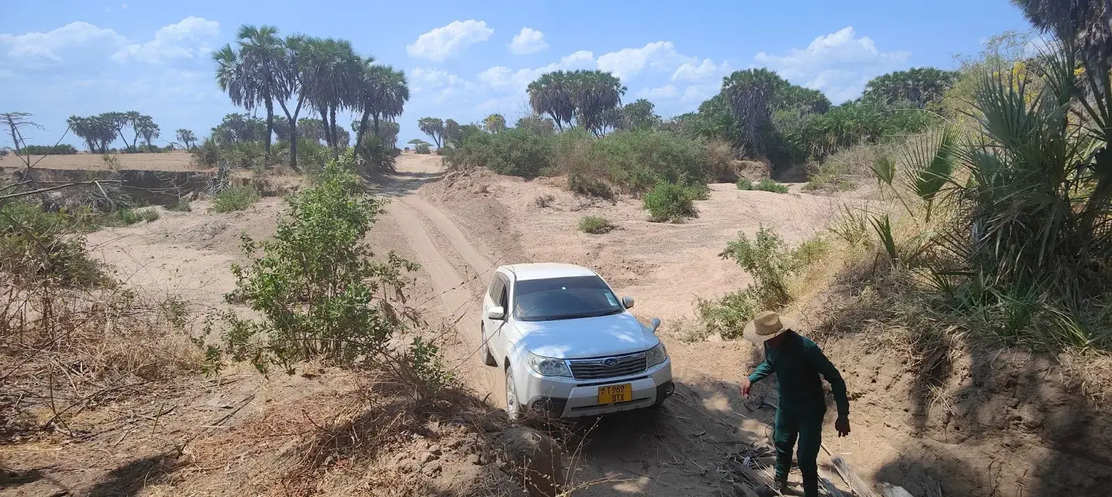
In the 200-kilometer field trip he undertook from Dar es Salaam to the Selous reserve, Brutelle noted that none of the villagers and fishermen who could be the first affected by the project knew about the dam’s existence. Their knowledge on the mangrove’s importance, however, was well integrated into people’s minds.
“Even when reaching Mtanza, the closest village to the ongoing construction site, people knew little to nothing about what was at stake there,” he says. “It’s only once passing the gates of the reserve that the harsh reality strikes—and in a rather eerie vision of massive construction trucks passing, one after another, in the reserve main roads, with seemingly small rangers cars occupied by tourists being overwhelmed by continuous clouds of dust.”
There, a former park guard agreed to lead him to the construction site in a complicated trip through the reserve. But they were later stopped by public authorities. Ironically enough, the immediate negative impacts of this megaproject were already promoted on the Egyptian company Arab Contractor’s corporate website: There, drone footage artistically captures noisy explosions filmed by employees.
“It was ironic to have been stopped from approaching the site, only to find this being publicly accessible on YouTube,” says Brutelle. Noise and dust are understood to be a continuous source of endangerment and nuisance to the animals in the park, as confirmed by the former guard the team interviewed on site. The same guard also reported several road incidents happening in connection with the dam.
This is also where Orieschnig came back on the front line of the research by mapping endangered species located in the immediate vicinity of the dam, thanks to available information from the Joint Research Center’s DOPA tool (Digital Observatory for Protected Areas).
“Available spatially distributed biodiversity data shows that 12 endangered species are to be found in the immediate vicinity of the park. Among them are the African bush elephant, the Masai giraffe, and the hooded vulture,” she explains in the article.

There are hundreds of species on the site whose survival depends directly on the Rufiji Delta and its water flow. If this delicate ecosystem is disturbed, it could very well provoke the scenario that the IUCN and UNESCO have already warned about, in addition to the depletion of mangrove forests downstream, said to be one of the largest in East Africa.
The team, however, confronted a main difficulty for the development of its projected hydrological model over the Rufiji: Despite having retrieved key technical and environmental information from the government and the companies themselves, including the megaproject’s contract, predicted flowing levels of the dam were nowhere to be found among the hundreds of pages at the team’s disposal.
“This information seemed like such a key one that we just didn’t think it wouldn’t show in all the official documentation we had received,” says Brutelle. “We took it for granted that it had to show up in this data, and while it showed a great lack of accountability and transparency over the initiators of the Nyerere Power Plant, it just wasn’t enough for us to draw a clear projection over the dam’s impacts on the mangrove, as we had intended.”
Just as in any investigation, available data should be assessed over and over before a project begins, explains Brutelle. This one allowed the team to understand that resorting to remote sensing requires double vigilance over the intended methodology and the data sources.
Despite this report being welcomed by media platforms Veza (Center for Collaborative Investigative Journalism), InfoNile, Africa Brief, and Daraj, it wasn’t published in Tanzania, which says a lot about the state of the media in the country, according to Brutelle.


